The Stairway to Heaven
In this post we will describe in some details one of the main technologies of the humanity, that is objects flying in the space… satellites!
Also, we will describe how they are useful to you.
Satellites are one of the most fascinating inventions. Today, we will describe the main ones developed for Earth Observation Missions by the European Space Agency (ESA) [1] [2] used for Earth observations and useful for the solar energy sector.
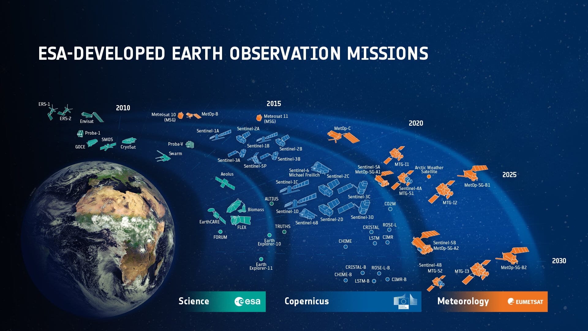
Figure 1: from ESA
Satellites come in different flavours. One of the main differences is the kind of orbit. The two most used orbits are the polar orbit and the geostationary orbit.
A polar orbit is one in which a satellite passes above or nearly above both poles on each revolution (look at the fig!). A satellite in a polar orbit will pass over the equator at a different longitude on each of its orbits. They are used when you need to have a global coverage of the Earth, and you have time to do it: if fact, the satellite usually takes 100 minutes to complete a full North Pole-South Pole circle, and in the meantime the Earth will rotate. Thus, the next orbit will take data for a different Earth area, and to complete the Earth coverage you usually need some days.
The geostationary orbit is a circular geosynchronous orbit 35,786 kilometres above Earth equator (look at the fig!). Thus, it is synchronous with the Earth motion and so to ground observers it appears motionless, in a fixed position in the sky. They are used when you need data of the same area with a high frequency (ex: 15 minutes).
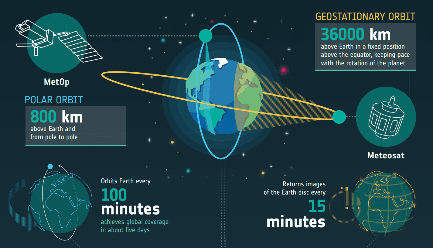
Figure 2: Example of two satellites with polar orbit (Metop) or geostationary orbit (Meteosat). From ESA
The Why
Thanks to the satellites can understand the complexities of our planet: today’s satellites are used to forecast the weather, answer important Earth-science questions, provide essential information to improve agricultural practices, maritime safety, help when disaster strikes, and all manner of everyday applications. In the following, I listed some of the most important operative (and some historically important ones) satellite missions from ESA, their goal and their applications. Since at i-EM we provide several services using satellite, I listed them, too. Feel free to contact us for additional details!
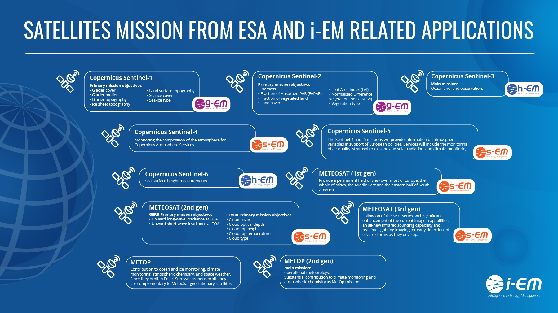
Figure 3: A list of ESA satellite programs and i-EM related applications. Click on the image to zoom.
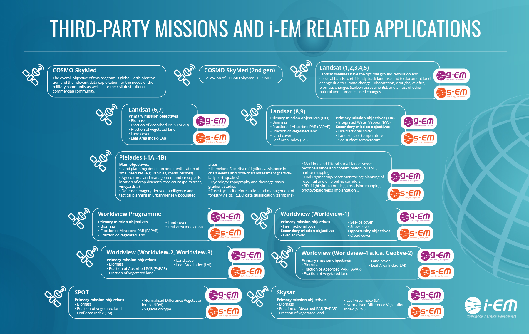
Figure 4: A list of thid-party satellite programs and i-EM related applications. Click on the image to zoom.
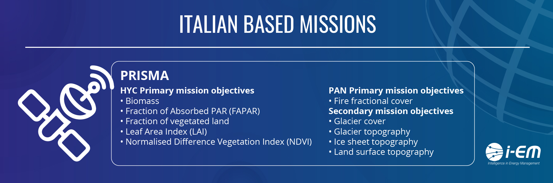
Figure 5
ESA SATELLITE MISSIONS
| Name of programme [1] | Goal [2] | Techs | Key Facts | i-EM Related Applications | Operative Period |
| Copernicus Sentinel-1 programme (satellites: Sentinel-1A, 1B,1C,1D) |
Sentinel-1 carries an advanced radar instrument to provide an all-weather, day-and-night supply of imagery of Earth’s surface. Primary mission objectives |
SAR-C: Synthetic Aperture Radar (C-band, frequency 5.405 GHz). Resolution: 4 m to 80 m, depending on operation mode. Coverage: Global coverage in 5 days – 3 months, depending on operation mode |
It allows monitoring of Arctic sea-ice extent, surveillance of the marine environment, including oil-spill monitoring and ship detection for maritime security, monitoring land-surface for motion risks, mapping for forest, water and soil management and mapping to support humanitarian aid and crisis situations. | g-EM | Sentinel 1A: 2014 -> 2021 Sentinel 1B: 2016 ->2023 Sentinel 1C: 2022 ->2029 Sentinel 1D: 2023 ->2030 |
| Copernicus Sentinel-2 programme (satellites: Sentinel-2A, 2B,2C,2D) |
High-resolution land observation, vegetation, territory management and hazards mitigation Primary mission objectives • Biomass • Fraction of Absorbed PAR (FAPAR) • Fraction of vegetated land • Land cover • Leaf Area Index (LAI) • Normalised Difference Vegetation Index (NDVI) • Vegetation type |
MSI: Multi-Spectral Imager for Sentinel-2 (13 channel in VIS/NIR/SWIR) Resolution: IFOV: 10 to 60 m, depending on channel Coverage: Global coverage in 10 days, in daylight. More frequent possible for emergencies |
The mission mainly provides information for agricultural and forestry practices, for helping manage food security and provide effective vegetation growth prediction. Sentinel-2 can be used to map changes in land cover and to monitor the world’s forests. It also provides information on pollution in lakes and coastal waters. Images of floods, volcanic eruptions and landslides contribute to disaster mapping and help humanitarian relief efforts. |
g-EM | Sentinel 2A: 2015 -> 2022 Sentinel 2B: 2017 ->2024 Sentinel 2C: 2022 ->2029 Sentinel 2D: 2023 ->2030 |
| Copernicus Sentinel-3 programme (satellites: Sentinel-3A, 3B,3C,3D) |
Main mission: ocean and land observation. | DORIS: Doppler Orbitography and Radiopositioning Integrated by Satellite GPS: GPS Receiver LRR: Laser Retro-Reflector MWR: Micro-Wave Radiometer OLCI: Ocean and Land Colour Imager SLSTR: Sea and Land Surface Temperature Radiometer SRAL: Synthetic aperture Radar Altimeter |
Sentinel-3 measures systematically Earth’s oceans, land, ice and atmosphere to monitor and understand large-scale global dynamics. It provides essential information in near-real time for ocean and weather forecasting. With a focus towards our oceans, Sentinel-3 measures the temperature, colour and height of the sea surface as well as the thickness of sea ice. These measurements will be used, for example, to monitor changes in sea level, marine pollution and biological productivity. Over land, it monitors wildfires, maps the way land is used, provides indices of vegetation state and measure the height of rivers and lakes – complementing the high-resolution measurements of its sister mission Sentinel-2. |
h-EM | Sentinel 3A: 2016 -> 2023 Sentinel 3B: 2018 ->2025 Sentinel 3C: 2023 ->2030 Sentinel 3D: 2025 ->2032 |
| Copernicus Sentinel-4 programme (Meteosat Third Generation satellites MTG-Sounder and MTG-Imager) |
Monitoring the composition of the atmosphere for Copernicus Atmosphere Services. | UVN: Ultraviolet Visible Near-infrared spectrometer (on MTG-S) IRS: Eumetsat’s thermal InfraRed Sounder (on MTG-S) FCI: Eumetsat’s Flexible Combined Imager (on MTG-I) |
The Sentinel-4 mission will provide information on atmospheric variables in support of European policies. Services will include the monitoring of air quality, stratospheric ozone and solar radiation, and climate monitoring. | s-EM | MTG-Sounder (MTG-S): >= 2023->2031 MTG-Imager (MTG-I): >= 2022->2030 |
| Copernicus Sentinel-5 (MetOp Second Generation satellite) | The Sentinel-5 mission will provide information on atmospheric variables in support of European policies. Services will include the monitoring of air quality, stratospheric ozone and solar radiation, and climate monitoring. | UVNS: Ultraviolet Visible Near-infrared Shortwave IRS: Eumetsat’s thermal InfraRed Sounder VII: the Eumetsat’s Visible Infrared Imager 3MI: Multi-viewing Multi-channel Multi-polarization Imager. |
Sentinel-5 mission comprises an Ultraviolet Visible Near-infrared Shortwave (UVNS) spectrometer and data from Eumetsat’s IRS, the Visible Infrared Imager (VII) and the Multi-viewing Multi-channel Multi-polarization Imager (3MI). | s-EM | Metop-SG-A1: 2023->2030 |
| Copernicus Sentinel-6 programme (Sentinel-6 Michael Freilich and Sentinel-6B) | Sea-surface height measurements | Poseidon-4: dual-frequency (C-band and Ku-band) radar altimeter | Sea-surface height measurements. It also provides near-realtime measurements of sea-surface height, significant-wave height and wind speed to support operational oceanography. Over land surfaces, Sentinel-6 provides information on the height of rivers and lakes in support of hydrology applications. | h-EM | Sentinel-6 Michael Freilich: >= 2020->2030 Sentinel-6B) >= 2025 -> 2030 |
| Meteosat first generation (Meteosat-1, Meteosat-2, Meteosat-3, Meteosat-4, (Meteosat-5, Meteosat-6, Meteosat-7) |
Provide a permanent field of view over most of Europe, the whole of Africa, the Middle East and the eastern half of South America | MVIRI: Meteosat Visible Infra-Red Imager (3 VIS/TIR channels) IFOV: 5.0 km for IR channels, 2.5 km for the VIS channel; Coverage: Full disk every 30 min. |
Multi-purpose imagery and wind derivation by tracking clouds and water vapour features | s-EM | 1977 -> 2006 |
| Meteosat second generation (Meteosat-8, Meteosat-9, Meteosat-10, Meteosat-11) |
A series of four Meteosat Second Generation (MSG) satellites provide more comprehensive and more frequent data to meteorologists and climate-monitoring scientists. GERB Primary mission objectives SEVIRI Primary mission objectives |
GERB: Geostationary Earth Radiation Budget Two broad-band channels, for solar reflected radiance and total reflected/emitted radiance SEVIRI: Spinning Enhanced Visible Infra-Red Imager. |
The new satellites are able to monitor the weather closely and quickly enough to allow accurate predictions of adverse weather over the next few hours anywhere over the MSG ‘footprint’. That means airports get earlier warnings of impending fog, local authorities knowing when to grit the roads in advance of a cold snap, construction companies can better plan for wet weather and farmers being able to effectively plan harvests. | s-EM | 2002 -> 2033 |
| Meteosat third generation | Follow-on of the MSG series, with significant enhancement of the current imager capabilities, an all-new infrared sounding capability and realtime lightning imaging for early detection of severe storms as they develop. | IRS: Eumetsat’s thermal InfraRed Sounder (on MTG-S) FCI: Eumetsat’s Flexible Combined Imager (on MTG-I) LI: Lightning Imager (on MTG-I) UVN: Ultra-violet, Visible and Near-infrared sounder (on MTG-S) |
The combination of MTG’s increased resolution and sensitivity of the imaging data and state of the art sounding products will take weather forecasting capabilities to the next level, particularly in the challenging task of ‘nowcasting’. | s-EM | 2021-> |
| METOP (MetOp-A, MetOp-B, MetOp-C) | Contribution to ocean and ice monitoring, climate monitoring, atmospheric chemistry, and space weather. Since they orbit in Polar, Sun-synchronous orbit, they are complementary to MeteoSat geostationary satellites |
Advanced Microwave Sounding Unit-A (AMSU-A) Advanced Scatterometer (ASCAT) Advanced Very High Resolution Radiometer (AVHRR/3) Global Navigation Satellite System Receiver for Atmospheric Sounding (GRAS) Infrared Atmospheric Sounding Interferometer (IASI) Microwave Humidity Sounder (MHS) Space Environment Monitor (SEM) |
The Meteorological Operational satellite programme (MetOp) is a European undertaking providing weather data services to monitor the climate and improve weather forecasts | MetOp-A: 2006->2021 MetOp-B: 2012->2024 MetOp-C: 2018->2027 |
|
| METOP second generation (MetOp-SG-A, MetOp-SG-B) |
Main mission: operational meteorology. Substantial contribution to climate monitoring and atmospheric chemistry as MetOp mission. |
On MetOp-SG-A: On MetOp-SG-B: |
MetOp-SG is a cooperative undertaking between ESA and Eumetsat, the European Organisation for the Exploitation of Meteorological Satellites. These new satellites offer enhanced continuity of the current MetOp series, today’s main source of global weather data. |
MetOp-SG-A: 2023-> … MetOp-SG-B: 2024-> … |
Table 1: ESA main Earth Observing Missions source: ESA website https://www.esa.int/Applications/Observing_the_Earth/Earth_observing_missions , WMO Oscar https://www.wmo-sat.info/oscar/
THIRD-PARTY MISSIONS
ESA also acquires, processes, archives and distributes data from other satellites so-called Third-Party Missions. The data from these missions is distributed under specific agreements with the owners or operators of the mission.
| Name of programme | Goal | Techs | Key Facts | i-EM Related Applications | Operative Period |
| COSMO-SkyMed |
Constellation of Small Satellites for Mediterranean basin Observation (COSMO) The overall objective of this program is global Earth observation and the relevant data exploitation for the needs of the military community as well as for the civil (institutional, commercial) community. |
SAR-2000: Synthetic Aperture Radar 2000 (X-band): High-resolution all-weather multi-purpose imager for ocean, land and ice. Resolution: 1 to 100 m, depending on operation mode |
COSMO-SkyMed is a 4-spacecraft constellation, conceived by ASI (Agenzia Spaziale Italiana), and funded by the Italian Ministry of Research (MUR) and the Italian Ministry of Defense (MOD), Italy. Each of the four satellites is equipped with a SAR (Synthetic Aperture Radar) instrument and is capable of operating in all visibility conditions at high resolution and in real time |
CSK-1: 2007->2020 CSK-2: 2007->2020 CSK-3: 2008->2020 CSK-4: 2010->2020 |
|
| COSMO-SkyMed (Second Generation) | Follow-on of COSMO-SkyMed. COSMO | CSG-SAR: COSMO-SkyMed Second Generation Synthetic Aperture Radar (X-band). High-resolution all-weather multi-purpose imager for ocean, land and ice. Resolution: 0.35 to 40 m, depending on operation mode. Global coverage in 10 days, target on 36 hours in emergency |
COSMO-SkyMed Second Generation is a 2-spacecraft constellation, conceived by ASI (Agenzia Spaziale Italiana), | CSG-1: 2019->2026 CSG-2: 2020->2027 |
|
| Landsat (1,2,3,4,5) |
The Landsat Program is a series of Earth-observing satellite missions jointly managed by NASA and the U.S. Geological Survey with a sun-synchronous orbit. Landsat satellites have the optimal ground resolution and spectral bands to efficiently track land use and to document land change due to climate change, urbanization, drought, wildfire, biomass changes (carbon assessments), and a host of other natural and human-caused changes. |
MSS (Multi Spectral Scanner) High-resolution land and vegetation observation, 4 VIS/NIR channels RBV (Return-Beam Vidicon camera), High-resolution land and vegetation observation, 3 VIS/NIR channels Resolution: 80 m Global coverage in 18 days |
The Landsat Program’s continuous archive (1972-present) provides essential land change data and trending information not otherwise available. Landsat represents the world’s longest continuously acquired collection of space-based moderate-resolution land remote sensing data. | (1972->2011) | |
| Landsat (6,7) |
Primary mission objectives • Biomass |
ETM+ (Enhanced Thematic Mapper+), Land and vegetation observation, 8 channels (6 narrow-band in VIS/NIR/SWIR, one PAN, one in TIR) (on Landsat 7) |
Follow-up and upgrade of previous Landsat | Landsat 6 (failed) |
|
| Landsat (8, 9) | Primary mission objectives (OLI)
Primary mission objectives (TIRS) Secondary mission objectives |
OLI: Operational Land Imager: High-resolution land and vegetation observation: 9 VIS/NIR/SWIR narrow-band channels, including one panchromatic (PAN)
TIRS Thermal Infra-Red Sensor, High-resolution land and vegetation observation: 2 TIR channels Resolution: 100 m, Global coverage in 8 days |
Follow-up and upgrade of previous Landsat | Landsat 8: 2013-> Landsat 9: expected 2021-> |
|
| Pleiades (-1A, -1B) |
Main objectives: • Land planning: detection and identification of small features (e.g. vehicles, roads, bushes) |
HiRI (High-Resolution Imager): Very-high-resolution land and vegetation observation. Digital Elevation Model (DEM). Two parallel radiometers, 5 VNIR channels, 4 multi-spectral (MS), one panchromatic (PAN).HiRI (High-Resolution Imager): Very-high-resolution land and vegetation observation. Digital Elevation Model (DEM). Two parallel radiometers, 5 VNIR channels, 4 multi-spectral (MS), one panchromatic (PAN).Resolution 2.8 m (MS), 0.7 m (PAN). Global coverage in 26 days, in daylight. With strategic pointing, one place can be observed every 2 days. |
Pleiades is a two-spacecraft constellation of CNES, introducing advanced technologies in Earth observation. Starting with the first launch in 2011, the Pleiades programme follows the SPOT programme satellite series services. The identical twin satellites in sun synchronous orbit deliver very-high optical resolution (0.5m resolution) and offer a daily revisit capability to any point on the globe. |
Pleiades-1A: 2011-> 2022 Pleiades -1B: 2012-> 2022 |
|
| Worldview programme | Primary mission objectives • Biomass • Fraction of Absorbed PAR (FAPAR) • Fraction of vegetated land • Land cover • Leaf Area Index (LAI) |
BGIS-2000 (Ball Global Imaging System 2000): Very-high-resolution land imagery. 5-channel VIS/NIR radiometer with one panchromatic channel and 4 multi-spectral. Resolution: 0.60 m (panchromatic), 2.4 m (multi-spectral). Global coverage in 6 months, in daylight; in few days (down to 7) by strategic pointing |
Commercially-based programme (DigitalGlobe), it is a series of satellites for high-resolution land observation. | Quickbird: 2001->2015 | |
| Worldview (Worldview-1) |
Primary mission objectives
Secondary mission objectives Opportunity objectives |
WV60 (World View 60 camera): Very-high-resolution land imagery. One panchromatic channel, 400-900 nm. Resolution: 0.50 m Global coverage in 6 months, in daylight; in few days (down to 3) by strategic pointing |
Commercially-based programme (DigitalGlobe), it is a series of satellites for high-resolution land observation. The WorldView-1 satellite was launched on 18 September 2007 and became the world’s first 50 cm resolution commercial imaging satellite. | Worldview-1: 2007->2020 | |
| Worldview (Worldview-2, Worldview-3) |
Primary mission objectives • Biomass • Fraction of Absorbed PAR (FAPAR) • Fraction of vegetated land • Land cover • Leaf Area Index (LAI) |
WV1100 (World View 60 camera): Very-high-resolution land imagery. 9-channel VIS/NIR radiometer with one panchromatic channel and 8 multi-spectral Resolution: 0.46 m (panchromatic), 1.84 m (multi-spectral) |
Commercially-based programme (DigitalGlobe), it is a series of satellites for high-resolution land observation. | Worldview-2: 2009->2022 Worldview-3: 2014->2021 |
|
| Worldview (Worldview-4, previously known as GeoEye-2) |
Primary mission objectives • Biomass • Fraction of Absorbed PAR (FAPAR) • Fraction of vegetated land • Land cover • Leaf Area Index (LAI) |
SpaceView-110 Imaging System: Very-high-resolution land imagery. 5-channel VIS/NIR radiometer with one panchromatic channel and 4 multi-spectral. 110-cm telescope Resolution: 0.31 m (panchromatic), 1.24 m (multi-spectral) Global coverage in 6 months, in daylight; in few days (down to 3) by strategic pointing |
Commercially-based programme (DigitalGlobe), it is a series of satellites for high-resolution land observation. | Worldview-4: 2016->2023 (he spacecraft suffered a failure in one of its control moment gyroscopes in January 2019, and operations were unable to be recovered) | |
| Skysat | The constellation’s goal is to be able to provide high-resolution satellite imagery of any place on Earth multiple times a dayThe constellation’s goal is to be able to provide high-resolution satellite imagery of any place on Earth multiple times a day Primary mission objectives• Biomass• Fraction of Absorbed PAR (FAPAR)• Fraction of vegetated land• Leaf Area Index (LAI)• Normalised Difference Vegetation Index (NDVI) |
SkySat (Very-high-resolution land imagery).SkySat (Very-high-resolution land imagery).5-channel VIS/NIR radiometer with panchromatic channel and 4 multi-spectral.Resolution 0.9 m (panchromatic) and 2.0 m (multispectral).Global coverage in one year, in daylight |
Commercially-based programme (Terra Bella -> Planet). Series of sun synchronous satellites for high-resolution land observation. The SkySats are about the size of a mini-refrigerator |
Skysat-1->Skysat21 | |
| SPOT | Primary mission objectives • Biomass • Fraction of vegetated land • Leaf Area Index (LAI) • Normalised Difference Vegetation Index (NDVI) • Vegetation type |
HRV (Haute Résolution dans le Visible) HRV (Haute Résolution dans le Visible) High-resolution land and vegetation observation. Digital Elevation Model (DEM)Two parallel radiometers, 4 VIS/NIR channels, three multi-spectral (MS), one panchromatic (PAN) Flown on SPOT-1 (1986-2003), SPOT-2 (1990-2009), SPOT-3 (1993-1996).Resolution 20 m (MS), 10 m (PAN).Global coverage in 26 days, in daylight. With strategic pointing, one place can be observed every 3 days.DORIS (Doppler Orbitography and Radiopositioning Integrated by Satellite)POAM: Polar Ozone and Aerosol MeasurementHRVIR: Haute Résolution dans le Visible et l’Infra-Rouge: High-resolution land and vegetation observation. Digital Elevation Model (DEM).Resolution: 20 m (MS), 10 m (PAN).Global coverage in 26 days, in daylight. With strategic pointing, one place can be observed every 3 days. (on SPOT-4)HRG: Haute Résolution Géométrique, High-resolution land and vegetation observation. Digital Elevation Model (DEM).Two parallel radiometers, 5 VIS/NIR/SWIR channels, 4 multi-spectral (MS), one panchromatic (PAN) Resolution 10 m (the three VNIR channels), 20 m (the SWIR channel), 5 m (PAN) with super-mode at 2.5 mGlobal coverage in 26 days, in daylight. With strategic pointing, one place can be observed every 3 days. (on spot-5) | Series of sun synchronous operational satellites, for high-resolution optical land observation. | SPOT1 ->SPOT7 |
Table 2: main Third-party Earth Observing Missions; source: ESA website https://earth.esa.int/web/guest/missions/3rd-party-missions/overview , WMO Oscar https://www.wmo-sat.info/oscar/
ITALIAN BASED MISSIONS
| Name of programme | Goal | Techs | Key Facts | Operative Period |
| PRISMA | HYC Primary mission objectives • Biomass • Fraction of Absorbed PAR (FAPAR) • Fraction of vegetated land • Leaf Area Index (LAI) • Normalised Difference Vegetation Index (NDVI) PAN Primary mission objectives • Fire fractional cover Secondary mission objectives • Glacier cover • Glacier topography • Ice sheet topography • Land surface topography | HYC: HYperspectral Camera. High-resolution hyperspectral observation of land, vegetation, inner waters and costal zones. Prism spectrometer for two bands (VNIR and NIR/SWIR). Resolution 30 m at s.s.p.Global coverage in 3 months, or down to few days depending on strategic pointing. PAN: Panchromatic Camera: High-resolution observation of land, vegetation, inner waters and costal zones.Panchromatic channel.Resolution 5 m at s.s.p.Global coverage in 3 months, or down to few day depending on strategic pointing | Single-satellite programme, for land and vegetation observation via sunsynchronous orbit under ASI sponsorship. PRISMA has innovative electro-optical instrumentation which combines a hyperspectral sensor with a medium-resolution panchromatic camera. The advantages of this combination are that in addition to the classical capability of observation based on the recognition of the geometrical characteristics of the scene, there is the one offered by hyperspectral sensors which can determine the chemical-physical composition of objects present on the scene. | PRISMA: 2019->2024 |
Table 3: WMO Oscar https://www.wmo-sat.info/oscar/

For the curious costumer
At i-EM S.r.l., we have what you need – we hope!
Try us! Find out more in our Solar assessment service or contact us.
Once upon a time: if you want to know the tale…
The European Space Agency (ESA) Established in 1975 and headquartered in Paris, ESA has a worldwide staff of about 2,200 in 2018 and an annual budget of about €6.68 billion in 2020.
The Italian Space Agency (ASI) is a government agency established in 1988 to fund, regulate and coordinate space exploration activities in Italy. Nationally, ASI is responsible for both drafting the National Aerospace Plan and ensuring it is carried out.
The first man-made satellite was…
Sputnik 1 was the first artificial Earth satellite. The Soviet Union launched it into an elliptical low Earth orbit on 4 October 1957. It orbited for three weeks before its batteries died and then orbited silently for two months before it fell back into the atmosphere. It was a polished metal sphere 58 cm in diameter with four external radio antennas to broadcast radio pulses. The satellite’s unanticipated success precipitated the American Sputnik crisis and triggered the Space Race, part of the Cold War. The name “Sputnik” is Russian for spouse/traveling companion or satellite when interpreted in an astronomical context. [source: Wikipedia]
The physics behind
The main idea is that a satellite is (like) a projectile. Once shot, the only force governing the motion of a satellite is the force of gravity. (Did you know? Newton was the first to theorize that a projectile launched with sufficient speed would actually orbit the earth, while studying the… Newton laws!). Problem is: when you shoot your soccer ball, it usually doesn’t go on a geostationary orbit… So, what’s the trick? If the initial speed is too small, every object would eventually fall to the ground. But if launched with sufficient speed, the projectile velocity can counter the gravitational force. The minimum velocity to escape the gravitational influence of the Earth is called escape velocity, and is the speed at which the sum of an object’s kinetic energy and its gravitational potential energy is equal to zero. In approximate formula (for a spherically symmetric Earth and a point-like flying object), you have:
0.5 *m(object)*v(object)^2 = G*M(Earth)*m(object) /r
- v(object) = sqrt(2*G* M(Earth) /r)
Where G is the universal gravitational constant (G ≈ 6.67×10⁻¹¹ m3·kg−1·s−2) and r the distance from the center of mass of the Earth to the object.
Setting some numbers: M(Earth) = 5.972 × 10^24 kg; radius of the Earth = 6371 km
- escape velocity = 11.2 km/s
which is approximately 33 times the speed of sound.
Pay attention: this is the velocity needed just to go away from the Earth and never come back, not to have a stable orbit such as a satellite.
Today, all satellites get into orbit by riding on a rocket (the main famous are the space shuttle, and recently the Falcon rocket from the Space-X company). Once the rocket reaches extremely thin air, at about 193 kilometres up, the rocket’s navigational system fires small rockets, just enough to turn the launch vehicle into a horizontal position. The satellite is then released.
Author

Fabrizio Ruffini, PhD
Senior Data Scientist at i-EM