
One day, Steve Jobs said, “I would trade all of my technology for an evening with Socrates.” This is how we should consider technology today, as a tool in the service of humanity, a means to enable humans to dedicate themselves to something greater, much like what happened in ancient Mesopotamia millennia ago with the invention of the wheel.
Perhaps it’s time for humans to wake up and devote their time to something else? Many are not yet aware and resist evolution to some extent because they are too entrenched in their daily routines. However, the answer is “yes,” and we could boldly state it, as demonstrated by the technological advancements in recent decades in the fields of Artificial Intelligence (AI) and machine learning.
Data collection and processing represent a significant expenditure of energy and a substantial amount of work that can truly be delegated to automatic systems. This allows humans to focus on what is more important: the responsibility of making decisions.
These systems are genuine business tools, through which business processes can evolve, making companies more competitive and ready to explore new scenarios.
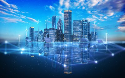
If we consider satellite observations, we can understand how they are used to assist our work. The data and images from space are an “inexhaustible” source, available 24/7. Today, in contrast to late 1960s when the first satellite was launched, there are now more than 4,500 satellites in space, and one of the significant advantages of these tools is related to the quality and quantity of the information they provide.
Satellites, despite the vast distances that separate them from the Earth, can provide highly detailed information. The resolution of commercial satellites can reach a few centimetres, which is incredible. Often, special equipment is installed on them to capture what escapes the human eye because it cannot detect certain frequencies. This is why the combination of these systems with our work can achieve significant levels of sophistication.
Satellites can be geostationary or polar orbiting, each with different functions. Those used for monitoring renewable energies are designed to collect data related to sustainable energy resources. If we delve into the main types of satellites, we can get a rough idea of their uses.
Types of satellites
Weather Satellites: Provide data on weather and climate, including parameters like cloud cover, solar radiation, and wind speed. This data is essential for observing and predicting solar energy availability.
Solar Irradiance Monitoring Satellites: Designed to estimate solar irradiance on Earth, providing crucial information about the amount of solar energy available in different regions.
Vegetation Monitoring Satellites: Use optical and infrared sensors to monitor the health of vegetation and plant cover in each area. This data can be used to estimate biomass production, which can be utilized for bioenergy production.
Land Use Monitoring Satellites: Provide information about land use, including areas dedicated to solar or wind energy, allowing continuous monitoring of renewable resources and human activities in the areas of interest.
Communication Satellites for Internet Access in Remote Areas: Use constellations of satellites in low Earth orbit to provide Internet access in remote or poorly connected regions, powered by solar energy.

Using high-resolution (HR) satellites to determine the construction progress of a 180 MW plant in Peru.
Services offered by satellites
Let’s provide a practical example of how this system can be used in the context of renewable energy.
If we were to decide to invest in and create a new solar facility, how useful would it be to use data from space and know in advance if the investment can be advantageous?
i-EM’s effort is to converge millions of data points, subject them to sophisticated mathematical formulas to accurately determine the output of a photovoltaic array (PV). These formulas go beyond just solar irradiance and also incorporate critical environmental parameters like temperature and wind speed. It’s a comprehensive effort, a perfect harmony between data and complex algorithms. As a result of the entire process, the essential information required to precisely evaluate the amount of available sunlight in the area designated for the photovoltaic system installation is acquired.
Satellite technology offers further value and can also be used during the construction phase of the facility. Through satellites, it’s possible to obtain periodic images that document the progress of the installation. For large-scale projects, this remote system is genuinely helpful and reduces all the costs associated with on-site supervision.
After site selection and facility construction, what is the role of satellite technology for a facility?
We harness solar irradiance information almost in real-time, with a frequency ranging from every 5 to 15 minutes, depending on the type of satellite used. This rapid data collection allows users to have precise and updated control of their energy facility’s performance. For the solar energy sector, solar irradiance nowcasting is conventionally calculated by extrapolating cloud positions into the future using satellite images (Cloud Motion Vector techniques). But today, all the competitive advantages of Artificial Intelligence (AI) and machine learning are added to the mix.
Once irradiance nowcast is obtained, we can proceed with forecasting the solar energy produced by the facility, managing the forecast activity for a more detailed medium-term planning. In this case, satellite data, both historical and real-time, is used to train algorithms.
Utilizing tools that are in space and providing a different perspective are a valuable resource for qualitative and quantitative management of the photovoltaic facility.
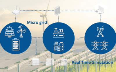
They are “assistants” in identifying the problem to be solved, and when combined with a user-friendly tool like s-EM, the solar energy management system developed by i-EM, they make energy-related decisions easy.
About s-EM
s-EM is a Software as a Service (SaaS) that monitors the real-time status of a solar installation, up to predictive activity. It is a solution that can be integrated into any type of installation, easy to use, intuitive in its operation, and suitable for any type of operator. It is available in standard or advanced diagnostics versions, it can be implemented with various plug-ins to add quality enhancements to your solar installation: solar plant power nowcast and forecast, predictive maintenance, drone data management, solar sensor check, satellite-based plant construction monitoring, self-consumption management.In conclusion
One day, Einstein said, “Everything should be made as simple as possible, but not simpler.” Isn’t this the value of technology today? To make human life simpler to live, but certainly not trivial.
Keywords
Analytics, Data Science, Data Analytics, Data Acquisition, Data Exploration, Solar Forecast, Solar Nowcast, Solar Power Prediction, Grid Management, Smartgrid, Satellite, Space